

segunda-feira, 31 de março de 2014
A semana começou com muita chuva em praticamente todo o país
A semana começou com muita chuva em praticamente todo o país. Cenário que se deverá manter ao longo dos próximos dias.
O IPMA tem todo o país sob aviso amarelo, devido aos períodos de chuva ou aguaceiros que poderão ser fortes e acompanhados de trovoada.
Imagem de satélite actual, e radar de precipitação.


Por MeteoPT
domingo, 30 de março de 2014
Microsoft lança chamada de projetos sobre mudança climática
Com o propósito de ajudar a prever impactos das mudanças climáticas e formas de lidar com eles, a Microsoft Research lançou um concurso para projetos de pesquisa sobre o tema que utilizem computação cloud.


Quarenta selecionados poderão usar gratuitamente os recursos da plataforma Windows Azure (Microsoft Research)
O programa Climate Data Award apoiará 40 projetos, permitindo uso gratuito de recursos de computação cloud da plataforma Windows Azure ao longo de 12 meses.
Cada projeto terá até 180 mil horas de tempo de computação e 20 terabytes de espaço de armazenamento cloud. Além disso, serão oferecidas sessões de treino para que os investigadores aprendam a utilizar as ferramentas desse recurso.
O Windows Azure é uma plataforma criada para o desenvolvimento e o organização de aplicações e serviços na web. Esses serviços podem ser simples, como uma página na web, ou complexos como uma ferramenta para explorar imensas coleções de dados.
Serão selecionados projetos que apresentarem ideias originais e permitirem avanços nas pesquisas utilizando o Windows Azure. As propostas devem ser submetidas até o dia 15 de Junho.
Devem descrever o problema de pesquisa e a sua importância e incluir uma estimativa dos recursos necessários, como requisitos de armazenamento, por exemplo.
O formulário de inscrições e mais informações sobre o programa podem ser visualizados em: http://blogs.msdn.com/b/msr_er/archive/2014/03/19/microsoft-research-support-for-climate-change-studies.aspx
Por MundoGeo
sábado, 29 de março de 2014
Previsão para os próximos 3 dias
Domingo a passagem de uma frente fria irá condicionar o estado do tempo logo a partir do inicio da manha no Litoral oeste com chuva passando a regime de aguaceiros ao longo do dia a chuva irá se deslocando também ás regiões do Interior não é de descartar a possibilidade de trovoadas localizadas, Segunda feira será um dia de grande instabilidade com a passagem de aguaceiros acompanhados de trovoadas e possibilidade de queda de granizo ou saraiva, Terça feira será um dia muito idêntico aos de Segunda de novo com bastantes aguaceiros acompanhados de trovoadas e podendo ser acompanhados de queda de granizo ou saraiva! Atenção para o risco ainda que baixo de formação de fenómenos localmente extremos (downburst / tornados) tanto Segunda como Terça!

Por MeteoAlerta
Garmin lança tablet com GPS, Wi-Fi e sistema operacional Android

A Garmin do Brasil, empresa que atua na área da navegação por satélite, apresenta o Monterra, o primeiro tablet com GPS e Wi-Fi, que une a alta sensibilidade do GPS, com a versatilidade do sistema operacional Android, permitindo a utilização de aplicações. O modelo é direcionado para práticas outdoor e, também, automóveis e marítimas, oferecendo aos profissionais que trabalham externamente e aos entusiastas, a capacidade de personalizar seu dispositivo GPS para atender necessidades pessoais ou profissionais.
Para completar o modelo, entre as características do Monterra estão: rádio FM, sensor UV, proteção à prova de água avaliada em IPX7, conectividade Wi-Fi, ANT+ e Bluetooth 3.0, MapMerge 3D (recurso para visualização de mapas em 3D), câmara de 8MP com foco automático, vídeo HD de 1080p com flash/lanterna LED com georreferenciação do local, capacidade de até 64GB de memória e bateria de li-ion recarregável, com autonomia para até 22 horas com uma única carga, ou mesmo as tradicionais pilhas AA.
O dispositivo possui também visor de vidro mineral altamente resistente, que utiliza a energia do sol para proporcionar a melhor legibilidade em qualquer situação. Dessa forma, a luz de LED é utilizada a noite ou em condições de pouca iluminação.
Com uma tecnologia de última geração, o Monterra oferece ainda o receptor GPS e Glonass de dupla frequência e alta sensibilidade, que encontra a localização rapidamente e mantém a captura do sinal, mesmo em vegetação densa e vales profundos. Para aprimorar o posicionamento, o Monterra possui uma bússola de três eixos incorporada a um acelerómetro, que indica a direção do utilizador quando ele está parado ou não tem o dispositivo na posição horizontal.
Com um altímetro barométrico, uma vez calibrado, o Monterra monitorizar as mudanças de pressão para definir a altitude exata e, também, monitorizar a pressão barométrica de acordo com o tempo, o que pode ajudar o utilizador a perceber as mudanças climáticas. Com um sensor de UV incorporado, é possível saber ainda o nível de exposição à luz solar, para que se possa evitar danos causados pelo sol, especialmente em locais mais altos e em superfícies brilhantes ou refletoras.
Sistema operacional Android
Com o sistema operativo Android, o Monterra permite que os utilizadores descarreguem as suas aplicações favoritas, através do Google Play. É possível aceder também a aplicações profissionais, como mapeamento de dados, para aumentar a eficiência diária em campo.
MapMerge 3D
Com um recurso de mapeamento único, o MapMerge 3D permite que os utilizadores possam combinar dois mapas como, topo, mapa base ou BirdsEye Satellite Imagery e, assim, ver o novo mapa em três dimensões únicas. Montes, vales, lagos, estradas e pontos de interesse, que se combinam para dar aos mapas do aparelho, detalhes de inigualável riqueza.
Para aceder ao vídeo disponibilizado pela Garmin vá a: http://www.youtube.com/watch?v=gRf52AP4Rn4
Por MundoGeo
sexta-feira, 28 de março de 2014
Funnel Cloud captada na Baía do Seixal

O que é?
Durante a tarde de hoje, a instabilidade deverá continuar no território continental. São esperados aguaceiros que poderão ser de granizo e acompanhados de trovoadas.
Por MeteoPT
quinta-feira, 27 de março de 2014

A Primavera insiste em não revelar a sua faceta mais calma, em particular no continente
Sábado deverá verificar-se uma acalmia, dando-se posteriormente início a um período bastante húmido, podendo estender-se até ao final da próxima semana, durante a qual se verificarão elevados acumulados de precipitação em grande parte do território continental.
Na Região Autónima da Madeira, também alguma precipitação a assinalar, particularmente na 6ªf. Durante esse dia, estarão activos avisos amarelos relativamente à intensidade do vento (rajadas da ordem dos 80 km/h) e ondulação, verificando-se igualmente um período de aviso laranja para este último parâmetro (ondulação até 7 metros).
Pela Região Autónoma dos Açores, nada de importante a assinalar, excepto uma descida da temperatura (em especial no grupo Ocidental) a partir de sábado.
Seguimentos em directo: http://bit.ly/qBGGmA
---
Imagens: precipitação acumulada em 3 horas entre as 18:00 UTC e as 21:00 UTC de hoje (5ª feira) [esquerda], precipitação acumulada entre as 00:00 UTC e as 03:00 UTC de 28 de Março, nebulosidade e isóbaras [centro], precipitação acumulada em 192 horas a partir das 18:00 de hoje (até às 18:00 UTC de 3 de Abril) [direita].

Por MeteoPT
Trimble lança plataforma online para profissionais do setor Geoespacial
A Trimble apresentou a “InSphere“, plataforma para gestão de informações geoespaciais. Segundo a empresa, trata-se de uma inovação metodológica para centralizar a gestão de operações geoespaciais, que melhora o fluxo de trabalho, aumenta a eficiência e transforma a maneira com que profissionais do setor geoespacial trabalham e acedem a informações importantes.


O InSphere é um software baseado numa plataforma cloud para gerir aplicações, dados e serviços geoespaciais. A estrutura simples e fácil de usar permite o acesso a múltiplas aplicações, incluindo três para aumentar a produtividade: Trimble InSphere Data Manager, Trimble InSphere Equipment Manager e o Trimble TerraFlex para simplificar a recolha de dados de campo. Além disso, o Trimble Access fornece um serviço de conexão de dados direto entre equipas no campo e gestores no escritório. O InSphere permite às organizações gerirem tudo num só lugar, sendo acessível a qualquer hora e em qualquer lugar.
O software Trimble Insphere já está disponível através da rede de distribuição geoespacial mundial da Trimble.
Uma versão de avaliação gratuita durante 90 dias está disponível para as ferramentas InSphere Equipment e Data Manager Online. Para ter acesso a informações mais detalhadas, visite o site: http://www.trimble.com/geospatial/insphere-cloud-software.
terça-feira, 25 de março de 2014
Ruckus lança nova tecnologia de posicionamento inteligente

A Ruckus Wireless, apresentou recentemente a tecnologia de posicionamento inteligente Ruckus SPoT™, o primeiro serviço deste tipo no setor para a localização inteligente baseada na cloud que permite que as operadoras/provedores de serviços e as empresas forneçam uma grande variedade de serviços de valor agregado nas redes Smart Wi-Fi da Ruckus para ajudar a aumentar sua rentabilidade e fornecer uma melhor experiência online aos seus utilizadores.
A ABI Research calcula que até 2017 o mercado de serviços de localização para locais fechados excederá a marca de 2 milhares de milhão de euros.
Diferente de outras soluções do setor oferecidas até o momento, o Ruckus SPoT reúne vantagens exclusivas, como ser totalmente baseado na cloud e oferecer precisão e desempenho aprimorados e mais efetivo em termos de custo.
Com a integração de um Algoritmo de Posicionamento para Interiores patenteado e obtido através da recente aquisição da YFind Technologies, pontos de acesso antigos e novos de Smart Wi-Fi da Ruckus podem agora fornecer posicionamento mais potente e preciso em locais fechados ou ambientes urbanos densos, onde o GPS nem sempre funciona.
Conhecendo a localização dos clientes as empresas podem ajudá-los a chegar onde precisam melhorando sua experiência da rede, ou utilizando dados da sua localização para otimizar a sua experiência. Além disso, as operadoras de redes podem fornecer aos utilizadores conteúdos relevantes à localização com base na proximidade dos pontos de interesse, inclusive ofertas de vendas oportunas – e até mesmo avisos de segurança.
Por MundoGeo
segunda-feira, 24 de março de 2014
Next-generation Multispectral LiDAR solution for shallow water surveys
Leica Geosystems and Airborne Hydrography AB announced the availability of CHIROPTERA II, an innovative LiDAR solution for topographic mapping and shallow water surveying in depths of up to 15 metres. The system simultaneously captures the full waveform in both the 35 kHz bathymetric channel and the 500 kHz topographic channel to provide high-detail maps for environmental and coastal monitoring, infrastructure planning, and other near-shore applications.

The latest version incorporates the industry-leading Leica RCD30 80-megapixel medium-format camera, NovAtel SPAN GNSS-IMU subsystem, Leica MissionPro mission planning software and Leica FlightPro flight navigation software. It also features a new scanner package that allows installation in the Leica PAV100 stabilised mount, providing perfect stabilisation and reducing the number of flight lines needed, especially in turbulent weather.

Being able to collect both bathymetric and high-point-density topographic data, plus high resolution aerial RGB images co-aligned with infrared images, all with a single sensor, opens a new field of applications within coastal monitoring, coastal assets inventory, sea-bed environmental monitoring, charting applications, infrastructural planning, coastal erosion monitoring, sea-bed classification and other applications.
Internet: www.airbornehydro.com/chiroptera-ii
Por GEOinformatics
domingo, 23 de março de 2014
Faro lança novo laser scanner Focus3D X 130
A Faro Technologies, empresa de tecnologia de medição, imagem e modelação 3D, anunciou o lançamento do novo Faro Laser Scanner Focus3D X 130.

O Focus3D X 130, o mais novo membro da série de scanners a laser Focus3D X, oferece enorme potência, design compacto e a flexibilidade para realizar varrimentos a laser em ambientes internos e externos. Com uma faixa de varrimento de 130 metros, esse scanner a laser é ideal para varrimentos de médio alcance, como nos casos de arquitetura, construção, engenharia civil, gestão de instalações, ciência forense, preservação histórica, produção industrial e construção naval.
Além disso, o laser scanner ultraportátil possibilita a medição rápida, clara e precisa de objetos e edifícios. Ao combinar a tecnologia de varrimento altamente precisa com a verdadeira mobilidade e facilidade de uso, esse novo dispositivo oferece confiabilidade, flexibilidade e visualizações em tempo real dos dados registados. Com seu receptor de GPS integrado, o scanner a laser é capaz de correlacionar varrimentos individuais no pós-processamento. Esses avanços no desempenho não comprometem a segurança, pois o Focus3D X 130 conta com um laser de classe 1 seguro para os olhos.
O ecrã tátil do Focus3D X 130 é tão fácil de operar como um smartphone”, afirmou Ralf Drews, diretor administrativo da Faro Europa. “Com uma bateria que dura 4,5 horas, o scanner a laser também conta com alto nível de flexibilidade e resistência. O pouco peso, o pequeno tamanho e o recurso de armazenamento de cartão SD do Focus3D fazem com que o scanner seja realmente móvel. Oferecemos essa qualidade a preços certamente únicos no mercado.”
Com a introdução do Focus3D X 130, a Faro oferece aos seus clientes uma opção entre os scanners a laser Focus3D X 130 de médio alcance (130 metros) e Focus3D X 330 de longo alcance (330 metros).
Por MundoGeo
sábado, 22 de março de 2014
Leica Nova MS50 MultiStation delivers first exact 3D scan of the Mont Blanc ice cap
Reaching the top of Mont Blanc, Europe’s highest peak, is a formidable challenge even to the most experienced alpinists - not only because of its elevation, but also because of its weather conditions. Strong winds and snowfall at the summit constantly cause altitude changes to the summit’s ice and snow cap. Such changes motivate expert surveyors to try out the latest in measurement technology, like the Chartered Land Surveyors located in the Upper Savoy region in France as well as two surveyors from Leica Geosystems France. For their seventh expedition, they decided to make the first ever 3D laser scan of the shape and volume of this legendary glacier using the Leica Nova MS50 MultiStation.


Towards the end of 2013, surveyors braved temperatures of -10⁰ C and winds of over 50 km/h, and set up a Leica Viva GS14 GNSS antenna to measure the height and also take roughly 100 point measurements of the ice cap. The Leica MS50 MultiStation scanned the ice cap at an altitude of over 4,800 m under extreme conditions and recorded thousands of points in a matter of minutes.


The 2013 expedition proved that the current elevation of Mont Blanc is 4,810.02 m, which is 42 cm less than in 2011. The actual rock summit has an altitude of 4792 m, however the snow covering the peak may vary the actual summit’s altitude anywhere from 15 to 20 m. Expedition partner Géomédia calculated the volume of the ice cap covering the rocky summit at 20,213 m³ and produced a 3D animation from the scan data as well. In the future, these results will help researchers determine possible changes to the ice cap caused by global warming.
Internet: www.leica-geosystems.com/ms50_montblanc_shortfilm
Por GEOinformatics
sexta-feira, 21 de março de 2014
Russia planeia lançar novo satélite Glonass em Março
A Rússia está a planear lançar um novo satélite de navegação Glonass-M em órbita no dia 24 de Março, de acordo com o Ministério da Defesa do país.
“O dia 24 de Março foi determinado como a data mais ideal para lançamento do Glonass-M”, disse o coronel Alexei Zolotukhin, porta-voz das Forças de Defesa Aeroespaciais.

Zolotukhin disse que o satélite será lançado do centro espacial de Plesetsk, no norte da Rússia, a bordo do foguete portador Soyuz-2.1b.
O novo Glonass-M irá juntar-se ao grupo de 28 satélites Glonass atualmente em órbita. Vinte e quatro satélites estão atualmente em operação, enquanto três servem como reposição e reserva e um está em fase de testes de voo.
O sistema Glonass requer pelo menos 18 satélites operacionais para que os serviços de navegação operem em todo o território russo e 24 satélites para fornecer serviços de navegação em todo o mundo. Até 2020, a Rússia planeia ter 30 Glonass-M de nova geração e satélites Glonass-K em órbita, incluindo seis de reserva.
quinta-feira, 20 de março de 2014
Pelas 16:57 UTC de hoje, dar-se-á início à Primavera.
No entanto, também a partir de hoje, verificar-se-á uma descida acentuada da temperatura, no continente. Esta será aliada à precipitação, que se fará sentir com mais intensidade durante o dia de amanhã, em especial na região Norte. Para sábado, ainda nesta zona, realce para eventuais aguaceiros que serão de neve a partir dos 800/1000 metros de altitude, podendo esta cota descer pontualmente aos 600 m na madrugada de domingo, nas regiões do Interior.
Nos grupos Ocidental e Central do arquipélago dos Açores, deverá igualmente ocorrer precipitação até domingo, podendo ser pontualmente intensa, em especial amanhã e sábado.
Por parte do IPMA, não existe nenhum aviso meteorológico activo neste momento.
Seguimentos em directo: http://bit.ly/qBGGmA
---
Imagens: Precipitação acumulada em 3h no período entre as 09:00 UTC e as 12:00 UTC de amanhã (21 de Março) [em cima], e temperatura aos 850 hPa (aproximadamente 1500 m) para Domingo, 23 de Março, às 00:00 UTC [em baixo].
![Foto: Pelas 16:57 UTC de hoje, dar-se-á início à Primavera.
No entanto, também a partir de hoje, verificar-se-á uma descida acentuada da temperatura, no continente. Esta será aliada à precipitação, que se fará sentir com mais intensidade durante o dia de amanhã, em especial na região Norte. Para sábado, ainda nesta zona, realce para eventuais aguaceiros que serão de neve a partir dos 800/1000 metros de altitude, podendo esta cota descer pontualmente aos 600 m na madrugada de domingo, nas regiões do Interior.
Nos grupos Ocidental e Central do arquipélago dos Açores, deverá igualmente ocorrer precipitação até domingo, podendo ser pontualmente intensa, em especial amanhã e sábado.
Por parte do IPMA, não existe nenhum aviso meteorológico activo neste momento.
Seguimentos em directo: http://bit.ly/qBGGmA
---
Imagens: Precipitação acumulada em 3h no período entre as 09:00 UTC e as 12:00 UTC de amanhã (21 de Março) [em cima], e temperatura aos 850 hPa (aproximadamente 1500 m) para Domingo, 23 de Março, às 00:00 UTC [em baixo].](https://scontent-b-mad.xx.fbcdn.net/hphotos-frc3/t1.0-9/s403x403/1911682_772980696045841_143380553_n.png)
Por meteopt
Satélite Cbers-4 será lançado em Dezembro deste ano

A Agência Espacial Brasileira (AEB) confirmou para a primeira quinzena de Dezembro o lançamento do Cbers-4, o quinto Satélite Chines-Brasileiro de Recursos Terrestres feito em parceria entre Brasil e China. O equipamento teve uma produção adiantada após o fracasso na tentativa de enviar ao espaço o Cbers-3, em Dezembro passado.
De acordo com a AEB, a montagem já é feita desde Dezembro de 2013 na China e no Brasil. O Instituto Nacional de pesquisas Espaciais (Inpe), de São José dos Campos (São Paulo), é o responsável pela produção do material no Brasil.
O Cbers-4 terá o mesmo formato e mecanismos do Cbers-3, com câmaras de observação da Terra mais modernas, segundo a AEB. O equipamento deve ser concluído em Setembro e transportado para a base de lançamento chinesa em Outubro, localizada na província de Sanxi, a 700 km de Pequim.
Apesar do corte sofrido de 10% no orçamento da agência brasileira – caiu de R$ 345 milhões em 2013 para R$ 310 milhões em 2014 – o investimento no novo satélite deve permanecer o mesmo aplicado no Cbers-3, cerca de R$ 160 milhões. A participação na construção permanece dividida em 50% para a China e 50% para o Brasil.
O equipamento tem como objetivo captar imagens que serão usadas pelo governo brasileiro e chines para monitorizar os setores agrícola, florestal, e no controlo do meio ambiente.
Para mais informações sobre o programa Cbers dirija-se ao site http://www.cbers.inpe.br/.
quarta-feira, 19 de março de 2014
Nações unem-se para criar a Infra-estrutura de Dados Espaciais do Ártico

No dia 20 de Fevereiro de 2014, em Reston (EUA), as organizações responsáveis pelas Agências Cartográficas e Cadastrais da Islândia, Groenlândia, Dinamarca, Noruega, Finlândia, Suécia, Rússia, Canadá e dos Estados Unidos estabeleceram um acordo de cooperação para promover a criação de uma Infra-estrutura de Dados Espaciais (IDE) do Ártico para os próximos 5 anos.
Segundo os organizadores, o objetivo principal desta IDE é estudar, com dados ambientais, as mudanças climáticas que afetam o nosso planeta e, especialmente, o Pólo Norte. O presidente do grupo para os próximos 4 anos será um representante do Canadá, o Diretor do Centro de Informações Topográficas de Recursos Naturais do país.
Mais informações sobre os planos do projeto estão disponíveis aqui.
Por MundoGeo
terça-feira, 18 de março de 2014
Esri lança mapas que ajudam a interpretar a crise na Crimeia
A Esri criou uma infografia na forma de mapa (Story Map) que ajuda a interpretar a crise na Crimeia e a tensão entre a Rússia e a Ucrânia. O Story Map está disponível para consulta aqui.

Ilustração 1 - Story Map ajuda a interpretar a crise na Crimeia e a tensão entre a Rússia e a Ucrânia
Os Story Maps utilizam a Geografia como uma forma de organizar e apresentar informação. Contam a história de um lugar, um evento, um assunto ou um padrão num contexto geográfico e de uma forma simples e apelativa. Os Story Maps combinam mapas iterativos com outros conteúdos como textos, fotografias, vídeos e som, numa experiência de utilização básica e muito intuitiva.
Para criar um Story Map, basta registar-se numa Conta Pública gratuita do ArcGIS Online, desenhar o seu mapa e criar uma aplicação web através dos templates disponibilizados gratuitamente pela Esri.
Para mais informações, visite a página dos Story Maps da Esri.
segunda-feira, 17 de março de 2014
CIJE'14 - Congresso Ibérico de Jovens Engenheiros
O CIJE’14 - 2º Congresso Ibérico de Jovens Engenheiros - vai realizar-se em A Coruña, no dia 21 de março de 2014, numa organização promovida pela Ordem dos Engenheiros (Portugal) e pelo Colegio de Ingenieros de Caminos, Canales y Puertos (Galiza).
O evento, dando continuidade ao CIJE’12, realizado em Braga, tem por base os temas: ‘Empreendedorismo’, ‘Internacionalização e Relações Transfronteiriças’, ‘Empregabilidade’ e ‘Inovação e Sustentabilidade’. Os principais objetivos são promover o desenvolvimento do engenheiro ibérico, fomentar as relações transfronteiriças e a partilha de oportunidades entre Portugal e Espanha.
Página do congresso: http://www.cije14.org/

Inscrições
A OERN disponibiliza o transporte e suporta 50€ sobre o valor da inscrição (inclui o coffee-break;almoço; livro de atas):
Inscrição geral: 150 €
Com comunicação aceite: 100 €
Estudantes de engenharia inscritos na Ordem dos Engenheiros: 50€
Engenheiros desempregados: 50 €
Aos estudantes inscritos irá ser cobrada uma caução no valor de 20€ que será devolvida após o encerramento do evento.
Saída do autocarro na Praça Francisco Sá Carneiro (Porto) prevista no dia 20 de Março às 17h00 com destino à Corunha. Haverá transporte desde Vila Real ou Braga caso o número de participantes o justifique.
Para reservas de hotel, por favor contacte a agência de viagens oficial do CIJE'14 - Viagens Orzán
silviaparga@viajesorzan.com ou viajesorzan@viajesorzan.com
Hotel Tryp Coruña, 20 a 21 de março
Alojamento (pequeno-almoço incluído) -> DUI y DUD - 50 €
Alojamento (meia pensão) -> DUI - 60 € y DUD - 70 €
Hotel NH Atlántico, 20 a 21 de março
Alojamento (pequeno-almoço incluído) -> DUI - 75 €
IVA não incluído
domingo, 16 de março de 2014
RIEGL introduces the World’s first App for LiDAR Data Visualization on the iPad: RiALITY
Dive into the point cloud!
RIEGL proudly announces its new iPad point cloud viewer: RiALITY, now available for free in the iTunes App Store.
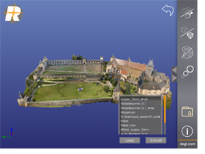
RIEGL Software RiALITY Screen
The App enables users to visualize and navigate through point clouds acquired with RIEGL laser scanners. As an example, users are able to explore a dataset of the beautiful Rosenburg Castle in Austria. RIEGL scans can also be imported from RiSCAN PRO software into the App, as well.
“We’re pleased to present a new way of visualizing point clouds. RiALITY delivers this new technology by providing Augmented Reality technology in an easy-to-use app. Now you can easily send your client a 3D point cloud that they can visualize on their iPad, for free.” says Ananda Fowler, RIEGL’s manager of terrestrial laser scanning software.
RiALITY features true color point clouds and 3D navigation. In a breakthrough technological development, the app features an Augmented Reality Mode. The Augmented Reality Mode allows point clouds to be virtually projected into the real world.
Find out more at www.riegl.com/app.
About RIEGL LMS:
RIEGL Laser Measurement Systems, Austria, is a performance leader in research, development and production of terrestrial, industrial, mobile and airborne laser scanning systems. RIEGL’s innovative hardware and software products provide powerful solutions for nearly all imaginable fields of application. For more information, visit www.riegl.com.
About RIEGL USA:
Located in Orlando, FL, RIEGL USA is the North American office for RIEGL Laser Measurement Systems, GmbH. With nearly 20 years of experience, RIEGLUSA delivers quality airborne, mobile and stationary terrestrial laser scanning solutions. For more Information, visit www.rieglusa.com .
Por gisresources
sábado, 15 de março de 2014
Telit lança novo módulo que permite rastreio de multi-constelações

A Telit Wireless Solutions, provedora de soluções, produtos e serviços M2M de alta qualidade, anunciou hoje o lançamento do Jupiter SL871. O novo módulo, que é baseado na tecnologia de baixo consumo core MT333 da MediaTek, permite o rastreamento de multi-constelações. O SL871 é a solução ideal para aplicações GNSS com baterias que não necessitam de navegação estimada, TRAIM e entradas de suportes de comunicação como USB. O recentemente lançado módulo de acompanhamento SL869 V2 fornece essas sofisticadas ferramentas.
O SL871 pode rastrear constelações GPS + Galileo e GLONASS (ou GPS + Galileo e Compass\Beidou), enquanto simultaneamente fornece dados de posicionamento através de um UART padrão. Ele possui ferramentas como um RF ultra sensível que permite posicionamento GNSS em locais cobertos, posicionamento rápido e navegação em lugares difíceis como áreas urbanas densas.
O Júpiter SL871 também suporta integração de dados de efemérides (A-GPS) para aumentar a precisão do posicionamento. Seu software é capaz de prever efemérides (tipo de sinais de gps) com três dias de antecedência começando com dados de efemérides transmitidas por satélites GNSS recebidas pelo módulo e armazenados na memória flash interna. Além disso, modos avançados de consumo de energia e AGPS ajudam a encontrar o melhor balanço entre precisão e consumo, aumentando de maneira significativa a vida da bateria.
Os desenvolvedores podem se beneficiar de uma integração facilitada entre os módulos celulares da Telit e o Júpiter SL871 quando projetarem aparelhos conectados com posicionamento. Juntar esses módulos de posicionamento e celulares reduzem a complexidade do desenvolvimento sem custos adicionais. Módulos multi GNSS combinados com os módulos eCall/ ERA-GLONASS podem, por exemplo, fornecer soluções de rastreamento automotivo de emergência para os mercados europeu e russo.
“A MediaTek está muito contente nessa parceria com a Telit em sua mais nova geração Júpiter de solução de posicionamento multi-GNSS”, disse SR Tsai, diretor da unidade de negócios em Wireless Connectivity e Networking da MediaTek’s, “A tecnologia de multi constelações da MediaTek tem sido aprovada globalmente. O MT3333 permite os melhores níveis de performance e integração, junto com o menor consumo de energia, e é ideal para o desenvolvimento entre diferentes segmentos de produtos.”
“O Júpiter SL871 foi projetado para ajudar desenvolvedores que procuram por uma maneira fácil e rápida de criar produtos com funcionalidade de geo-localização, particularmente aqueles movidos por bateria”, disse Taneli Tuurnala, vice presidente e chefe da divisão GNSS da Telit Wireless Solutions. “Esse módulo aumenta nossa parceria com a MediaTek e acelerará a nossa expansão global em áreas como sistemas de gerenciamento de frota, tecnologia portátil, navegação automotiva, telemática e monitores pessoais, entre outras”.
Com mais de uma década no foco exclusivo ao M2M, reduzindo os riscos técnicos e o tempo de implementação para integradores, a Telit é a parada única para tudo relacionado ao M2M. A Telit alavancou o mais amplo portfólio de tecnologias celular, curto alcance e posicionamento da indústria aliado aos serviços de sua unidade de negócios m2mAIR que cobre capacitação de aplicações além de rede móvel e conectividade por internet/nuvem. Os produtos e serviços da Telit são entregues com suporte e logísticas globais que excedem os requerimentos de clientes grandes ou pequenos.
Por MundoGeo
sexta-feira, 14 de março de 2014
Global Precipitation Measurement Mission Launches Successfully
The world has enters a new era of global weather observing and climate science on February 27, 2014, at 1:38 p.m. Eastern Standard Time.
GPM, a joint mission between NASA and the Japan Aerospace Exploration Agency (JAXA). The observatory will link data from a constellation of current and planned satellites to produce next-generation global measurements of rainfall and snowfall from space.

Image Courtesy: NASA Earth Observatory
The GPM mission is the first coordinated international satellite network to provide near real-time observations of rain and snow every three hours anywhere on the globe. The GPM Core Observatory anchors this network by providing observations on all types of precipitation. The observatory’s data acts as the measuring stick by which partner observations can be combined into a unified data set. The data will be used by scientists to study climate change, freshwater resources, floods and droughts, and hurricane formation and tracking.
The GPM Core Observatory, built by Goddard, will launch on an H-IIA rocket provided by JAXA. Mitsubishi Heavy Industries Ltd. is managing the launch.
The new satellite has two main sensors: the Global Precipitation Imager (GPI) and the Dual-Frequency Precipitation Radar (DPR). GMI is a microwave radiometer that will observe precipitation with 13 different microwave channels ranging in frequency from 10 GHz to 183 GHz. The DPR consists of a Ku-band precipitation radar (KuPR) and a Ka-band precipitation radar (KaPR) that will provide 3-D observations of rain and will also provide an accurate estimation of rainfall rate to the scientific community.
Together these two instruments should provide a database of measurements against which microwave observations made by a constellation of existing and future satellites can be meaningfully compared and combined to make a global precipitation data set. Collectively, GPM and its partner satellites will quantify when, where, and how much it rains and snows around the world.
Watch NASA GPM Rocket Launch
quinta-feira, 13 de março de 2014
Webinar discute sobre Mapa Inteligente e Cartografia nos Negócios
Prevenir desastres naturais e salvar vidas, ordenar e regularizar a instalação de grandes empreendimentos, promover certificações e selos verdes para produtores rurais, produzir e consultar mapas através de ferramentas de fácil utilização e cloud computing. Essas são algumas temáticas que serão abordadas por três especialistas da Geoambiente, no dia 26 de Março, a partir das 11h30 (horário de Portugal), no webinar promovido em parceria com a MundoGEO.
“Estamos a viver um ápice no uso da geotecnologia no Brasil. Basta ver as notícias para perceber o grande ênfase dado na preservação ambiental, nos temas relacionados com a instalação de grandes empreendimentos e nos sistemas de prevenção e mitigação em áreas de risco e situações de emergência. Já é sabido que a Cartografia é uma das principais mais-valias para gestão territorial, o que muda agora é o poder de utilização e o compartilhar dessa preciosa informação” comenta Izabel Cecarelli, diretora-presidente da Geoambiente.
Com um know-how de 20 anos no mercado de Geotecnologia, a Geoambiente está à frente de grandes e atuais projetos de mapeamento no Brasil. “Como referência, estamos a atuar no mapeamento da vegetação do Estado da Bahia, no ZEE do Litoral do Ceará e no mapeamento de áreas de risco de dezenas de municípios. Também contribuímos com o nosso conhecimento para que empresas obtenham certificações e licenciamentos ambientais, realizando estudos que envolvam Cartografia, Geotecnia e Meio Ambiente. Vale a pena conferir, pois muitos destes casos de sucesso serão retratados neste Webinar”, finaliza Izabel.

O seminário online abordará os temas:
• Mapas de suscetibilidade, riscos geológicos e geotécnicos – Conhecimento para salvar Vidas;
• Estudos, modelagem, gestão e monitoramento ambiental – Conhecimento para salvar o Planeta;
• Imagens de satélite, DEM, mapa de uso e ocupação do solo – Para um desenvolvimento Sustentável.
Com uma visão muito prática e objetiva, serão apresentados casos de sucesso em empresas e governos de diversos segmentos de atuação, tais como: Meio ambiente, Utilities, Óleo e Gás, Agronegócios, ONGs e Gestão Pública.
Os oradores serão: Justino Pinheiro, Geólogo formado pela UNESP e com mais de 30 anos de experiência na área ambiental e de cartografia; Ana Carolina Rezende, Eng. Agrónoma e Mestre em Deteção Remota pelo INPE com vasta experiência em estudos, modelagem e certificações ambientais; e Thiago Rodriguez, Mestre em Deteção Remota pelo INPE e um dos responsáveis técnicos pelos maiores projetos de mapeamento da atualidade.
Os participantes poderão interagir com os apresentadores, enviando suas questões através do chat. Após o webinar, serão enviados certificados digitais de participação a todos que estiverem online na sessão.
Webinar: Mapa Inteligente: Cartografia Aplicada aos Negócios
Data: 26 de Março de 2014
Hora: Das 11h30 às 12h30 (hora de Portugal)
Inscrições: https://www2.gotomeeting.com/register/541305610
quarta-feira, 12 de março de 2014
terça-feira, 11 de março de 2014
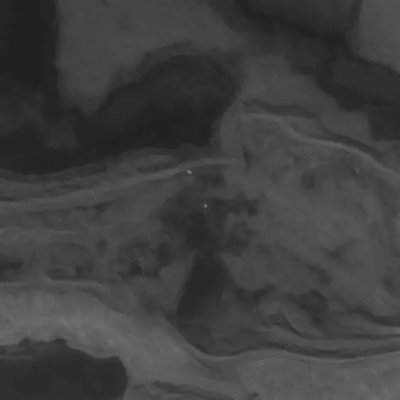
Bears from Space: Scientists Try to Count Polar Bears Using Satellite Imagery
They look like tiny white specks on a mottled grey background.
They’re polar bears seen from space — using the newest tool in the kit for scientists to monitor Canada’s populations of the mighty Arctic predator.
“They really do stand out as a bright white dot against that dark grey landscape,” said Seth Stapleton, a University of Minnesota scientist pioneering the technique.
High-resolution satellite images are being increasingly used by scientists to get a look at animals living in remote, expensive-to-reach places. They’ve already been used on penguins, walruses, seals and whales.
Stapleton, who specializes in new ways to estimate bear populations, said the idea to use satellite photos came up one day while he was in the field with a colleague.
“We jokingly discussed, wouldn’t it be funny if we could do this one day with something like Google Earth,” he said.
As it happens, a researcher who has done other work with satellite imagery teaches at the same university. They got together, came up with a research plan and took it from there.
Rowley Island was selected as a site because Stapleton knew it was flat, free of snow in the summer and popular with bears. He thought bears would show up well on the uninhabited expanse of rock and gravel between Baffin Island and Melville Peninsula.
Satellite images with resolution as tight as half a metre are commercially available. Stapleton purchased two sets, one taken August 2012 and one a month later.
“It’s not rocket science,” he said.
“This is a really simple idea. All we did was compare the two images and look for the white spots that changed between image A and image B.
“If there was a white spot that was on image A that was in the right spot, the right shape, the right colouration, but was not on the second image, then that was a pretty good indication that that was a polar bear.”
The scientists later flew over the island to ensure they hadn’t been fooled by bear-like objects such as large, light-coloured rocks or chunks of ice.
Stapleton said using satellite images has a lot of advantages.
It doesn’t disturb the bears and is safer for humans. It’s cheaper and easier to set up than traditional aerial surveys, meaning scientists can check on all populations more often than the current rate of once every 15 years.
But it only works on clear days and on terrain that contrasts with the bears.
“We’re a long, long way from detecting bears on snow and ice.”
Nor is a simple count enough information to assess a bear population, said Andrew Derocher, a University of Alberta polar bear expert.
“We need much more information to make an assessment of status — body condition, movements and distribution, reproductive rates, age structure, survival rates, sea-ice conditions and harvest rates,” he said.
“Without additional context and a comprehensive monitoring plan, remote sensing of polar bears can only provide some limited insights.”
Still, Derocher agrees that satellite counts could eventually become a useful tool to track population trends.
“My guess is that our methods will ultimately be non-invasive and … remote sensing will be part of the tools.
“The imagery available from remote sensing is improving year by year. Eventually, I’m sure technology will allow us to ‘see’ every polar bear on the sea ice, monitor their kills and count their cubs.”
Stapleton is working to improve the method. His first task will be to develop computerized counting to eliminate the drudgery of manually comparing images and counting bears.
“The applications are limited right now. I do think it’s a very promising technique.”
Anyone can try it.
“We decided to poke around on Google Earth,” said Stapleton. “We’re pretty darn sure we could see polar bears.”
Por The Canadian Press
They’re polar bears seen from space — using the newest tool in the kit for scientists to monitor Canada’s populations of the mighty Arctic predator.
High-resolution satellite images are being increasingly used by scientists to get a look at animals living in remote, expensive-to-reach places. They’ve already been used on penguins, walruses, seals and whales.
Stapleton, who specializes in new ways to estimate bear populations, said the idea to use satellite photos came up one day while he was in the field with a colleague.
Two polar bears (centre) show up as white dots on satellite imagery over Nunavut in 2012. High-resolution satellite images are being increasingly used by scientists to get a look at animals living in remote, expensive-to-reach places. THE CANADIAN PRESS/HO, Imagery courtesy of Digital Globe, Inc. ©2012
“We jokingly discussed, wouldn’t it be funny if we could do this one day with something like Google Earth,” he said.
As it happens, a researcher who has done other work with satellite imagery teaches at the same university. They got together, came up with a research plan and took it from there.
Rowley Island was selected as a site because Stapleton knew it was flat, free of snow in the summer and popular with bears. He thought bears would show up well on the uninhabited expanse of rock and gravel between Baffin Island and Melville Peninsula.
Satellite images with resolution as tight as half a metre are commercially available. Stapleton purchased two sets, one taken August 2012 and one a month later.
“It’s not rocket science,” he said.
“This is a really simple idea. All we did was compare the two images and look for the white spots that changed between image A and image B.
“If there was a white spot that was on image A that was in the right spot, the right shape, the right colouration, but was not on the second image, then that was a pretty good indication that that was a polar bear.”
The scientists later flew over the island to ensure they hadn’t been fooled by bear-like objects such as large, light-coloured rocks or chunks of ice.
Stapleton said using satellite images has a lot of advantages.
It doesn’t disturb the bears and is safer for humans. It’s cheaper and easier to set up than traditional aerial surveys, meaning scientists can check on all populations more often than the current rate of once every 15 years.
But it only works on clear days and on terrain that contrasts with the bears.
“We’re a long, long way from detecting bears on snow and ice.”
Nor is a simple count enough information to assess a bear population, said Andrew Derocher, a University of Alberta polar bear expert.
“We need much more information to make an assessment of status — body condition, movements and distribution, reproductive rates, age structure, survival rates, sea-ice conditions and harvest rates,” he said.
“Without additional context and a comprehensive monitoring plan, remote sensing of polar bears can only provide some limited insights.”
Still, Derocher agrees that satellite counts could eventually become a useful tool to track population trends.
“My guess is that our methods will ultimately be non-invasive and … remote sensing will be part of the tools.
“The imagery available from remote sensing is improving year by year. Eventually, I’m sure technology will allow us to ‘see’ every polar bear on the sea ice, monitor their kills and count their cubs.”
Stapleton is working to improve the method. His first task will be to develop computerized counting to eliminate the drudgery of manually comparing images and counting bears.
“The applications are limited right now. I do think it’s a very promising technique.”
Anyone can try it.
“We decided to poke around on Google Earth,” said Stapleton. “We’re pretty darn sure we could see polar bears.”
Por The Canadian Press
segunda-feira, 10 de março de 2014
Download e instalação da versão free trial do software ArcGIS 10.2
A versão 10.2 do ArcGIS foi lançada no dia 1 de Agosto de 2013. É um software global e, hoje, um dos mais utilizados por profissionais da área de Sistemas de Informação Geográfica (SIG).
Passo a passo
1. Entre no site www.esri.com/software/arcgis/arcgis-for-desktop/free-trial
2. Coloque o seu login e senha no site da Esri. Caso ainda não esteja registado, clique na opção para criar uma nova conta.

3. Na janela que se abrirá em seguida, clique na opção download do ArcGIS for Desktop.
4. Escolha o idioma em que será instalado o software.

5. Feito isto, você receberá um email com o código da licença demonstrativa (ex: EVA482359733) para ativar o software posteriormente.
6. Após a conclusão do download, clique duas vezes e execute o Setup do ArcGIS Desktop.
7. Clique em Next e em seguida seleccione a opção para aceitar o acordo de uso da licença.
8. Clique em Next novamente.
9. Selecione a opção para instalação completa do software e, em seguida, clique em Next nas próximas duas janelas e aguarde a instalação. Após a conclusão, clique em Finish.


Ativação
10. Com o software instalado, agora é hora de ativá-lo! Para isso, no seu computador, clique em Iniciar > Todos os Programas > ArcGIS > ArcGIS Administrator.
11. Com o ArcGIS Administrator aberto, seleccione a opção Advanced (ArcInfo) Single Use e em seguida clique no botão Authorize Now.


12. Selecione a opção “I have installed my software and need to authorize it” e então clique em avançar.
13. Selecione a opção “Authorize with Esri now using the Internet” e avance para o próximo passo.
14. Preencha o registo com suas informações e clique em avançar para ambas as janelas.
15. Na janela aberta, informe o código que você recebeu no seu email registado (ex: EVA123456789) e avance.
16. Na próxima etapa, marque a opção “I do not want to authorize any extensions at this time” e clique em avançar.
17. Selecione as extensões que você quiser utilizar (3D Analyst, Spatial Analyst ou Geostatistical Analyst, por exemplo).


18. Para finalizar, clique em avançar para que seja concluído o processo de validação da licença.
Pronto! Seu ArcGIS 10.2 está instalado e ativo por 60 dias.
Por MundoGeo
domingo, 9 de março de 2014
sábado, 8 de março de 2014
Novo satélite WorldView 3 fará imagens com muito mais resolução

Até o final de 2014, o satélite de última geração WorldView 3, fabricado pela Ball Aerospace, será responsável por gerar novas imagens da Terra com maior definição.
Operado pela DigitalGlobe, empresa que já fornece imagens para o Google, Microsoft e Apple, o novo satélite terá sua órbita a aproximados 600 quilómetros da Terra e uma velocidade de 8 quilómetros por segundo.

As lentes, que funcionarão como um telescópio, serão capazes de distinguir objetos de até 25 centímetros. No entanto, estas imagens tão aproximadas só estarão disponíveis para o governo dos Estados Unidos. Para o público geral que utiliza o Google Maps e o Goorgle Earth, por exemplo, o limite máximo será de 50 centímetros.
Além da definição das imagens, uma grande inovação deste dispositivo é que ele não fará apenas quadros estáticos, mas também imagens contínuas de faixas de terra ou água. Essas imagens vão contribuir desde o planeamento urbano até monitorização florestal, exploração de petróleo e cartografia. Como as imagens são disponibilizadas sob um custo, a atualização dos mapas depende do Google comprá-las e incluí-las no Google Maps.
Apesar das opções variarem entre Google, Bing Maps e Apple Maps, as imagens têm a mesma procedência – a DigitalGlobe. Entretanto, após a instalação de camaras inglesas na Estação Espacial Internacional, a canadense UrtheCast promete lançar uma nova tecnologia com imagens em tempo real, gratuitas e que em breve entrará em fase de testes.
sexta-feira, 7 de março de 2014
Leica Geosystems announces news for the Mobile GIS line Zeno
A Leica Geosystems, empresa suíça da área de soluções geoespaciais, anuncia uma série de novidades para a linha Zeno GIS.
Entre elas, estão as novas versões dos softwares de recolha de dados no campo e de escritório Zeno Field e Zeno Office, respectivamente, que são integrados diretamente com as soluções GIS da Esri ArcPad e ArcGIS.
Ainda, sobre o software de campo Zeno Field, agora é possível a sincronização na cloud, via ArcGIS Online, de projetos de campo e escritório entre os utilizadores envolvidos em ambos os ambientes. Quanto ao processamento de dados, o núcleo para pós-processamento L1 foi aperfeiçoado no software Zeno Office, além da possibilidade de armazenamento de dados brutos para o dispositivo móvel Zeno 5.
Por MundoGeo
quinta-feira, 6 de março de 2014
Google lança galeria de mapas disponível online
O Google lançou no dia 27 Fevereiro de 2014 o Google Maps Gallery, uma extensão do Programa de Dados Públicos do Google Maps, anunciado no mês de Outubro de 2013. A nova galeria tem como objetivo mostrar mapas das organizações que o Google tem parceria, como National Geographic, Banco Mundial, Serviço Geológico dos EUA, facilitando assim o acesso a vários mapas.

Ilustração 1 Novo Google Maps Gallery funciona como um Atlas digital interativo
De acordo com Jordan Breckenridge, diretor de produtos do Google, a ideia por trás do programa é disponibilizar os mapas e informações geoespaciais que as organizações já possuem. Muitas vezes estes dados não são facilmente encontrados pelo público ou os arquivos estão em formatos de imagens ou PDF. “Não é isso que a maioria dos utilizadores espera de mapas online hoje. A intenção aqui é fornecer um atlas digital interativo com conteúdos e mapas a todos no planeta”, afirma Breckenridge.
O Programa de Dados Públicos do Google selecionou alguns interessados para receber acesso livre à versão enterprise do Google Maps Engine. Isto facilitou o acesso a “conectores” que permitem importar os dados públicos das organizações dentro do Maps Engine. Alguns dos mapas disponíveis hoje usam esses conectores, enquanto outros apenas apresentam uma imagem de seus mapas existentes como um ‘overlay’ em cima da base de mapas do Google. Os editores permanecem no controlo da marca, modificação e licenciamento do conteúdo.
A ideia do novo Google Maps Gallery é facilitar o acesso aos mapas. Segundo o blog oficial do Google Maps, a ferramenta funciona como um Atlas digital de mapas, permitindo ao utilizador explorar planos de cidades, mudanças climáticas, acessibilidade das habitações, naufrágios e rotas de evacuação atualizadas, por exemplo. Breckenridge assume que a maioria das pessoas não vai necessariamente encontrar esses mapas no Gallery, mas através das ferramentas de buscas do Google.
Por MundoGeo
quarta-feira, 5 de março de 2014
Destaque para os próximos dias
Destaque para os próximos dias no continente: o deslocamento da área de influência anticiclónica para o eixo Açores/Golfo da Biscaia/Ilhas Britânicas permitirá a ocorrência dos primeiros dias de ambiente primaveril. Até ao final da semana, não é esperada ocorrência de precipitação, mantendo-se o céu, maioritariamente, pouco nublado ou limpo. As temperaturas deverão exceder os 20ºC em grande parte do território, já a partir de amanhã.
Uma benéfica pausa no tempo chuvoso que tem marcado este Inverno.
Seguimentos em directo: http://bit.ly/qBGGmA
---

Imagens: Temperatura a 2 m, previsão para as 15:00 UTC de 6ª feira (meteociel.fr) [esquerda], e carta meteorológica para as 09:00 UTC do mesmo dia (GFS MeteoPT) [direita].
Por MeteoPT
Introdução ao WebMapping com Software OpenSource
Nos últimos anos têm-se assistido à disseminação das aplicações Web de base geográfica em áreas tão variadas como em organismos públicos, turismo, agricultura, medicina, marketing, gestão, etc. Esta diversidade de utilizadores trouxe novos desafios à concepção desta aplicações. Com o aparecimento das tecnologias OpenSource aumentou exponencialmente a oferta de soluções para o seu desenvolvimento. A evolução das tecnologias Web concederam novas capacidades a este tipo de aplicações que vão além da mera visualização estática de mapas.

Calendarização: 12 e 13 de Maio de 2014
Horário: 09h00 às 18h00
Pré-inscrição: mediante preenchimento do seguinte formulário. A inscrição só se torna efetiva após apresentação do comprovativo da transferência bancária.
Mais informações:
Ordem dos Engenheiros Região Norte
Rua Rodrigues Sampaio, 123
4000-425 Porto
T - 22 207 13 00
F - 22 203 96 47
Email - formacao@oern.pt
Subscrever:
Mensagens (Atom)